Posts: 19
Threads: 9
Joined: Sep 2016
Reputation:
0
Fiefs: 69
09-01-2016, 02:16 AM
(This post was last modified: 11-04-2019, 06:33 PM by Ayzek.)
Siora
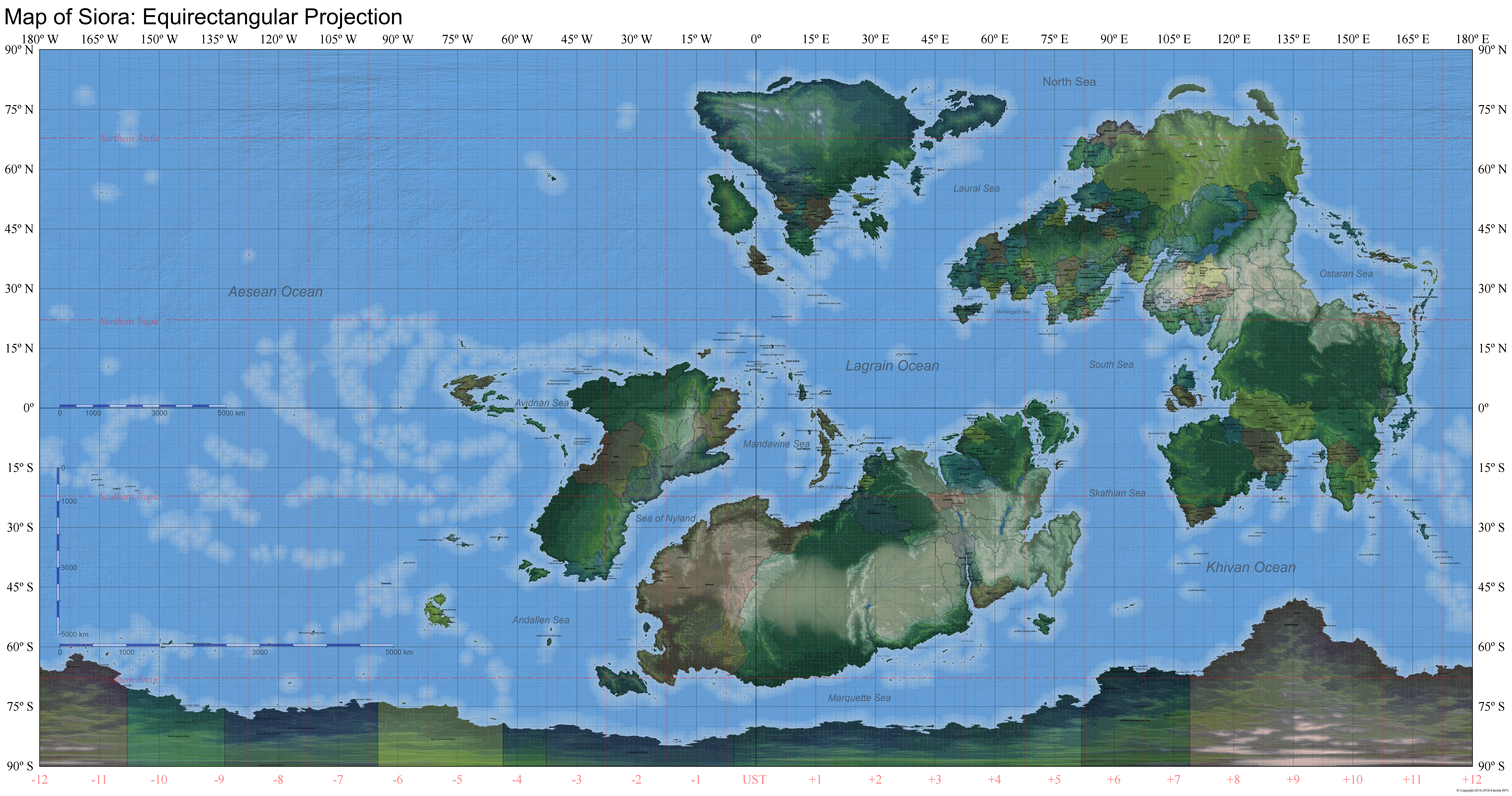
Siora is the planet all Modern-Tech Role Play nations inhabit. It is slightly larger than Earth, and has a history just as great and diverse. Its inhabitants are equally heterogeneous, though the various cultures are reasonably clustered together—as would be expected of a self-contained world. Though the world was once dominated by Brigidnan and Kvaennan colonial powers, it has grown more mutlipolar in recent decades. There are six continents on Siora: Avidna, Brigidna, Kvaenna, Ostara, Skathia, and Southerland. There are also three major distinct regions: Aeseanna, the Mandavine, and the Near East.
Show ContentAbout:
About Avidna
Avidna is the western-most continent, located east northwest of the Sea of nyland and southeast of the Aesean Ocean. This continent was subjected to colonization by Brigidnan and Kvaennan powers, though parts of it did manage to resist and prosper under indigenous cultures. Avidna can be classified as a second-world region, with an average GDP per capita of less than 25,000.
About Brigidna
Brigidna is the continent northeast of the Lagrain Ocean and spans to the North Sea west of the Bigass Mountains. Many states here are inspired by Europe and are populated by cultures and ethnicities based on European counterparts. Brigidna colonized much of the world with Kvaenna, though has given up much of it. Nowatimes, Brigidna is a charged region, with Imperialistic powers seeking to regain lost glory.
About Kvaenna
Kvaenna is the continent west of Brigidna, north of the Lagrain Ocean. It is inspired by Europe too, and engaged in colonization. To a lesser extent, it has the same challenges that rock Brigidnan states.
About Ostara
Ostara is the rest of the landmass that forms Brigidna, stretching from Brigidna to the Khivan Ocean in the south. It is a very diverse land, based loosely on Asia. Much of its southern extents were colonized by Brigidnan powers, though eastern coast largely escaped unscathed.
About Skathia
Skathia is the continent between Avidna and Ostara and north of the Marquette Sea. It is home to Nyland, the richest state on the planet. Much of Skathia was colonized by Brigidnan powers, with the except of its underbelly, which was largely protected by the massive desert that runs across the desert and the remoteness of its coast. While east Skathia is home to loosely African-inspired continents, the center and west have been largely reformed by the Brigidnan colonial masters.
About Khionna
Khionna is the continent that encompasses the South Pole. Interestingly, a part of the continent is warm enough to be inhabited year-round. The rest of the continent is divided among several powers, with a portion of it being an international zone where any state can build research facilities or attempt to exploit the continent. Stationing military forces on the continent is prohibited by international treaty.
About Aeseanna
"Aeseanna" refers to the many islands chains that fill the Aesean Ocean between Avidna and Ostara. It is home to islander cultures, who sailed their way across the islands from ancient homes on both Avidna and Ostara.
About the Mandavine
The Mandavine Islands are those east of Avidna and north of Skathia. Though technically part of the Avidnan continent, the Mandavine developed quite differently, being entirely subjected to Brigidnan domination. Much of it has since gained independence, though some holdouts remain. The Mandavine is very diverse, both culturally and economically.
About the Near East
The Near East refers to the peninsula south of Angiris and southwest of A'sir. It's a generally poor area, aside from the two beacons of stability in Angiris and Mestra. Need to say, it's inspired by the Middle-East.
Map
When claiming a country, please copy and use the land claim available here.
![[Image: 20191104.png]](http://board.eternityrpc.com/images/erpc/maps/standard/20191104.png)
Equirectangular Maps
Borders| Topography | Terrain
Cylindrical Equal-area Maps
Borders
2019 Log |
| Date | Changes |
|---|
| 20190428 |
Added Letravia (Juice), Videjeszeme (Oertha), and Dagroth (Zan); Merged Sappa/Harmajaa; edited Aurentine cities; moves E/W Kaljurand to new location. |
| 20191024 |
IDK |
[/tr]
| 20191027 |
Added Argead (Ayzek) |
| 20191104 |
Added Fotia (Arkiana) |
Posts: 871
Threads: 105
Joined: Jul 2016
Reputation:
20
Administration Team: 
Wiki Fiefs: 297.42
Fiefs: 997,994
09-02-2017, 10:21 PM
(This post was last modified: 11-11-2018, 01:18 AM by Ayzek.)
2016 December 28th

2016 January 13th

Show Content2016 Log:
2016 Log |
| 2016-12-28 |
Added Caralava (Colombian Technocracy); edited Volta cities; removed Corvania |
| 2016-10-05 |
Added Brigitta (TSCU), cities to Ga'bath; fixed misspelled names |
| 2016-08-28 |
Added Almaniania (Alvino), Galizia (Essky), Gloria (TGE), Isla Verde (Arthur); updated Kolhar (Zabuza) |
| 2016-07-31 |
Added Aflinland (HisWizardness), Tuscarawas (Anakinexi); Removed Detectatia, Moln and Pulne/w/e, Lietus, Luthwaffle, Mordorsica |
| 2016-07-03 |
Grand update to Marzanna, added Paradesh |
| 2016-03-07 |
Fixed border errors (A'sir, Kokina, Kortoa); added Zanarite cities; added Ahara (Carp/Ceausescu/Scimitarthief), Calgarov (Rommy/URE), Luwealthia, New Galasia (Zanaro), Shirakyu (doveofwar/Robba). Sunk island. |
| 2016-01-28 |
Added: Octitania, Sáppá (Eminence/Medaveii); cities to Goldecia (Brum Brum), Luah'u (Sal), Volta (Zabuza825). |
| 2016-01-13 |
Initial Release. |
Posts: 871
Threads: 105
Joined: Jul 2016
Reputation:
20
Administration Team:
Wiki Fiefs: 297.42
Fiefs: 997,994
11-11-2018, 01:16 AM
(This post was last modified: 11-11-2018, 01:19 AM by Ayzek.)
2017 November 24th

2017 February 9th

Show Content2017 Log:
2017 Log |
| 2017-11-24 |
Added Saeard (Joshua), ARC (Father Wi11iam); Reorganized Arkiana, Svarna Surya, Gehenna. |
| 2017-11-19 |
Added Evania (Rainbow); Removed Silvanias (jass), Vannusia (Batts), Solis (JakkuZakku24), Sainam (Austlen), Vestor Licit (CONCENTRAL), Chiri (STRATCOM), Sahalla, Damahal |
| 2017-11-06 |
Removed Sainam (Blac), Added Drubang (Flo) |
| 2017-11-01 |
Partitioned Balochia to Harmajaa and Severyane |
| 2017-10-06 |
Added Solis (JakkuZakku24) |
| 2017-07-13 |
Cosmetic changes; added Leines, Florinthus |
| 2017-06-25 |
Added Akau Mokupuni (Motherofzerg), Caparetta (Jam and Med) |
| 2017-06-18 |
Added Belayazemlya (BrumBrum) |
| 2017-06-05 |
Added Eretzora (Tivona Shneider), Drausany (His Wizardness) |
| 2017-05-14 |
Added Aeriland (URE), Mayari (Fal), Neuvant (Severyane), Nindaro (KawaiiPotato); removed Caralava; moved Hylis (Ayzek) |
| 2017-02-09 |
Added Vestor Licit (CONCENTRAL) and Licit Chiri (STRATCOM), Removed a whole bunch |
Posts: 926
Threads: 108
Joined: Sep 2016
Reputation:
8
Wiki Fiefs: 103.71
Fiefs: 3,581
11-12-2018, 06:58 PM
(This post was last modified: 11-12-2018, 07:10 PM by Hadash.)
![[Image: Mord.jpg]](https://i.postimg.cc/VvSH0bzQ/Mord.jpg) Cities for Mordvania:
Cities for Mordvania:
1 - Amsberg
2 - Mestarka
3 - Mazenskai
4 - Visnja
5 - Ryban
6 - Paviemes
7 - Snogen
8 - Zyrn
9 - Prindz
10 - Seznica
11 - Slovograd (capital)
12 - Brezedina
13 - Chlyb
14 - Opoblina
15 - Slawowo
16 - Dodzyn
17- Wojek
![[Image: Kyrzbek.jpg]](https://i.postimg.cc/xdhsD1K6/Kyrzbek.jpg) Cities for Kyrzbekistan:
Cities for Kyrzbekistan:
1 - Ayduramazan (capital)
2 - Qendere
3 - Dashkek
4 - Ersyre
5 - Lebrazdh
6 - Elene
7 - Magan
8 - Heribat
9 - Byzkhan
10 - Frasheri
11 - Ilib
12 - Takar
13 - Ashkabad
14 - Tarkek
And also:
0 - Can you move Ashar to somewhere nearby the left side of that river? It makes more sense there.
For just Khokharsa:
-Südenberg - somewhere on the southern/western coast.
Posts: 163
Threads: 25
Joined: Sep 2016
Reputation:
10
Administration Team: 
Wiki Fiefs: 0.00
Fiefs: 660
Official Name of State: Chikasun Republic
Common name of State: Chikasu
Economic Development: Developing Nation: Some cities have begun to modernize but tensions with other Heiwanan Successor States have made modernization difficult for the country. The capitol and a few other major cities have modern amenities; beyond these places much of the countryside is still struggling to catch up with infrastructure lacking in some places.
Population size: 38,248,948 (as put in the stats)
Size: As discussed, the borders of the nation from the expansion for Kazemura.
Location: North Ostara: Due Southeast/East of Kazemura up until the planned Sainam expansion state
Cities:- Eno (Capitol City): Somewhere in the middle of the large island
- Nonsan: West end of the large island
- Saito: East end of the large island
- Iwo: Between Eno and Saito, possibly along the South coast
- Segata: Between Nonsan and Eno, possibly along the North coast
Ethnicity: Heiwanan, Regional Ethnicity is mainly Chikasun with some Kazemuran people in the West end of the country. Similar to Japanese culture
Religion: 95% Fatalist (the regional religion), 5% Other or Did Not Answer
Brief description of your country: Born out of the ruines of the Heiwanan Empire’s demise, Chikasu is an amalgamation of the conquests of one of the branches of the House Sekai, long the rulers of Heiwana. Unfortunately for this branch, it would quickly meet its demise not by its rival branches or by any foreign power but instead by its own people. Tired of the cruel measures taken during the First Heiwanan Succession War, Chikasu’s people rose overthrew the aspiring Emperor and burned the Red Palace to the ground.
While many suspected the fall of Chikasu to one of the other players, surprisingly Chikasu emerged from the war relatively intact and brandishing a new democratic republic. It would face invasion in the Second and Third Heiwanan Succession Wars as it serves as the bridge between the East and West ends of the archipelago. These repeated invasions led to a near coup of the civilian government by the military which was averted in the final moments by pure luck and a steady Presedential hand. Unfortunately, this luck would not benefit Chikasu in keeping up with its neighbors in technological advancement as its Western neighbor Kazemura continues its climb to technological and economic dominance. This, as well as its continued hostilities for control over the archipelago has led to continued tensions.
However, the new Empress of Kazemura has attempted to pivot its government towards rapproachment. At a time when Sainam grows ever more aggressive in the East and Drubang grows ever more violent in the South, this could serve as a welcome reprieve for the Republic. But even now, some do not fully trust the Kazemurans. While their Empress means well, just one bad day could make her just like their cruel aspiring Emperor of old...
Chikasu now stands at a crossroads. Will it continue to stand alone against the growing storms? Or will it take Kazemura’s hand and fight side by side for the time being? Or perhaps, there’s a new path forward that has yet to reveal itself...
The only certainty is that Chikasu’s chosen path will reshape the North, and possibly all of Ostara, for years to come.
Brief Summary of how you'd like your country to fit in the world: Likely, it would stand with Kazemura due to some similarities in ideology. After the war it would hopefully hear out Kazemura’s federation proposal and push forward a more democratic federation that includes removing an imperial head of state in favor of a secular one, while ensuring the House Sekai carries out their function in a religious setting to avoid a complete collapse of culture/order.
Posts: 158
Threads: 22
Joined: Sep 2016
Reputation:
10
Administration Team: 
Wiki Fiefs: 0.01
Fiefs: 611
Please move Kaljurand to Mordvania's old plot and split it into East/West along the mountains. IDC where the cities go really, place them where it makes sense you're the mappyboi.
Posts: 453
Threads: 134
Joined: Sep 2016
Reputation:
3
Wiki Account: Goldecia
Wiki Fiefs: 0.00
Fiefs: 1,755
11-28-2018, 03:14 AM
(This post was last modified: 11-28-2018, 03:14 AM by BrumBrum.)
![[Image: W6TqU9o]](https://imgur.com/a/W6TqU9o)
Is it possible to have have this zone with Point Arthur on the post Camp Peter I , Camp Luther I , Camp Georgina I and Camp Edmund III. The zone would be under Royal Administration perhaps with a few hundred thousand on the continent depending on climate.The zone would be used for a mix of tourism and research purposes ans be a protected continent environmentally. The cruises to it would be run from Sheep Isles with possibly an airport at camp Arthur. The zone would be called Goldecian Royal Khionna. It would likely have been established sometime during a rush for Khionna.
Goldecian Royal Khionna
Is it possible to have have this zone with Point Arthur on the post Camp Peter I , Camp Luther I , Camp Georgina I and Camp Edmund III the camps would be mix of coastal and inland. The zone would be under Royal Administration perhaps with a few hundred thousand on the continent depending on climate.The zone would be used for a mix of tourism and research purposes ans be a protected continent environmentally. The cruises to it would be run from Sheep Isles with possibly an airport at camp Arthur. The zone would be called Goldecian Royal Khionna. It would likely have been established sometime during a rush for Khionna.Location would be between New Aldenan Khionna and Nyland Khionna.In terms of roleplay it could easily be used to roleplay scientific expeditions and monitoring of the climate and any ice melt(if there is any)
Posts: 1,544
Threads: 134
Joined: Sep 2016
Reputation:
27
Administration Team: 
Wiki Fiefs: 0.00
Fiefs: 2,205
(11-28-2018, 03:15 AM)BrumBrum Wrote: Goldecian Royal Khionna
Is it possible to have have this zone with Point Arthur on the post Camp Peter I , Camp Luther I , Camp Georgina I and Camp Edmund III the camps would be mix of coastal and inland. The zone would be under Royal Administration perhaps with a few hundred thousand on the continent depending on climate.The zone would be used for a mix of tourism and research purposes ans be a protected continent environmentally. The cruises to it would be run from Sheep Isles with possibly an airport at camp Arthur. The zone would be called Goldecian Royal Khionna. It would likely have been established sometime during a rush for Khionna.Location would be between New Aldenan Khionna and Nyland Khionna.In terms of roleplay it could easily be used to roleplay scientific expeditions and monitoring of the climate and any ice melt(if there is any)
No.
What you ask sits at or beyond the 80th degree parallel. Climate there is ice and rock. In the southern summer there is endless sun to beat down upon an icy, rocky desert, and in the southern winter you get to contemplate how much you enjoy -60 to -80 temperatures huddled within the infinite darkness of your icy, rocky tomb. There is no rush for anything there, unless you like rushing to your death: a "few hundred thousand" people would not ever visit this land in any the past, present, future, or alternate history of the world.
Camp Peter I and Camp Edmund III exist in Taeunasan Khionna. Camp Arthur I exists in the Khionna International Zone. As a Signatory to the Khionna Treaty (though even if you weren't) you're free to establish additional research stations. Goldecia has no right to claim or sole stewardship under the treaty, but shares in stewardship of the continent as party to the treaty.
Posts: 1
Threads: 0
Joined: Apr 2019
Reputation:
2
Wiki Fiefs: 69.25
Fiefs: 70
04-08-2019, 01:40 PM
(This post was last modified: 04-08-2019, 03:20 PM by Dagroth.)
Official Name of State: The Empire of Dagroth
Common name of State: Dagroth
Economic Development: Developing
Population size: Average
Size: Medium
![[Image: 2e7TebN.png]](https://i.imgur.com/2e7TebN.png) Location: Brigidna
Cities:
Chathair Impiriúil (Capital, central mountains), Caisleán Álainn (Coastal, south), Mournehold (Inland, Mountains), Ealden (coastal, north), Capalii (Near Ashford and Carp border)
Ethnicity:
Location: Brigidna
Cities:
Chathair Impiriúil (Capital, central mountains), Caisleán Álainn (Coastal, south), Mournehold (Inland, Mountains), Ealden (coastal, north), Capalii (Near Ashford and Carp border)
Ethnicity:
Dagrin
Religion:
no dominant religion
Brief description of your country
The Empire of Dagroth is a sovereign state located in Brigidna on a large penninsula near the center eastern edge of the continent. The nation is surrounded on the south and east side by the Pythian Sea, with the north having the Gulf of Dagroth, as well as the Estrek Plains. Several islands off the coast of the mainland are considered part of the nation. Eastern Dagroth, and Southern Dagroth have a tendency to have a maritime climate, while the inland parts are more continental. The Grand Kingdom of Ashford sits on the north-western border of Dagroth, The Allied States of Carpathia and Moldova sits on the northern border, The Principality of Felis and The Kingdom of Freesia sit on the south-western border of the Empire.
Dagroth has held a long tradition of Monarchism and nobility rule, with a fairly militant, and conservative rule the nation has not had to deal with the rise of a democratic faction. The Empire possesses an Absolute Monarchy, who is served by the various Praetors, and Dominai. The Emperor/Empress is considered the sole owner of all of the land within Dagroth, but the Praetors and Dominai rule in their stead. This has led to many Praetors to seek more land by proving that the other families do not deserve to rule it, often through military means.
Brief Summary of how you'd like your country to fit in the world
Military Power
Posts: 1,544
Threads: 134
Joined: Sep 2016
Reputation:
27
Administration Team:
Wiki Fiefs: 0.00
Fiefs: 2,205
Official Name of State:
Videjszemes Karaliste
Common name of State:
Videjszeme
Economic Development:
Well at this point rather developed. It mainly exports IT solutions. Outside the cities still has a lot of the country's old rural character.
Population size:
low lol. About a third of the old pop; perhaps about 6-7m
Size: Location: Cities:
![[Image: 9VqtbzO.png]](https://i.imgur.com/9VqtbzO.png) Ethnicity:
Ethnicity:
Still Latvian, bro
Religion:
primarily Sentric
Brief Summary of how you'd like your country to fit in the world
Lookiit that little guy go!
|


![[Image: Wbs3DMM.png]](http://i.imgur.com/Wbs3DMM.png)